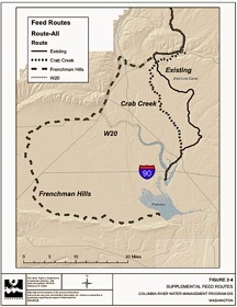
The U.S. Bureau of Reclamation has proposed using portions of Upper Crab Creek for even more conveyance of irrigation water. Click on map to enlarge.


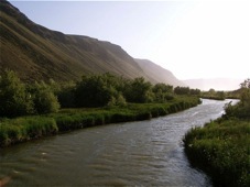
Lower Crab Creek and Saddle Mountains. John Osborn phoro


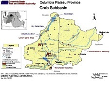
Map of the Crab Creek watershed.
Click on map to enlarge. From Crab Creek Subbasin Plan (Northwest Power & Conservation Council, 2004)
These agencies and organizations have a long record of protecting Crab Creek:
Crab Creek Dam
-
• flooding a National Wildlife Refuge - endangered fisheries - farms
-
• poster child for Washington’s failing water policy
-
• to see the State’s second pick for a new dam, click here
Home | Contact Us | About Us | Join CELP | Ralph W. Johnson
Center for
Environmental Law & Policy

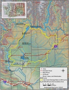
Lower Crab Creek
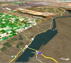
click on map and Google Earth image to enlarge


Columbia River and Crab Creek. I-90 bridge at Vantage in foreground.
(image: Google Earth)
The use of these logos does not imply endorsement of our website by these agencies and organization.
Brown trout from Nunnally Lake
(photo: Pacific FlyFishers)
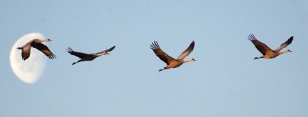
Sandhill Cranes, Crab Creek. Photo: Kathy Admire


Crab Creek Dam
The Columbia River is among the most heavily dammed rivers on Earth. Despite this fact, in 2005, Washington State embarked on a new dam-building program for the Columbia River basin. Click here for an overview of the program.
Washington’s dam-building program is coming to fruition in three areas:
1.the Yakima basin (including the Black Rock Dam proposal),
2.the Odessa Aquifer Subarea, and
3.the Columbia River “off-channel” project.
The Columbia Institute has already released reports on the Yakima and Odessa.
The Columbia off-channel dam program was initiated by a study, released in December 2005, that examined 21 possible damsites adjacent to the Columbia River, ranging from the Columbia Gorge to the Canadian border.
On June 8, 2007, Washington narrowed the list to three sites, and expressed its preference to build a new dam and reservoir site on Lower Crab Creek. See Washington’s “Columbia River Storage Options”. This website provides information about Crab Creek, the proposed dam, and its environmental and economic implications.
In a nutshell, Crab Creek is 140 miles (225 km) long and drains a vast area of more than 5,000 square miles (13,200 square km). It is thought to be the longest ephemeral stream in the United States. It originates near Reardan, Washington and flows southwest across the upper Columbia Plateau, feeding into Moses Lake and the Potholes Reservoir. From Potholes it turns westerly and travels for 30 miles before discharging into the Columbia River between Wanapum and Priest Rapids Dams (about 20 miles downstream from the Gorge Amphitheater).
Crab Creek is ecologically unique, but has been dramatically altered by the operations of the Bureau of Reclamation’s Columbia Basin Project (CBP), which uses parts of Crab Creek to both convey irrigation water to farmers, and to serve as a drainage canal. Indeed, the Bureau has proposed using portions of Upper Crab Creek for even more conveyance of irrigation water. The Columbia Institute filed comments on this flawed proposal: click here.
Lower Crab Creek is an environmentally valuable area, although it has been significantly altered by increased flows from upland irrigation. Ironically, it is one of the few streams in eastern Washington that now has more water than in its natural state. This has altered the ecosystem, but in a beneficial way.
Lower Crab Creek flows through a narrow and scenic valley that runs east-west between the Saddle Mountains and Frenchman Hills. Lower Crab Creek provides important fish, bird and wildlife habitat, including habitat for migrating steelhead. As the Northwest Power & Conservation Council notes: “The Crab Creek Subbasin offers enormous opportunity to conduct fisheries enhancement to help mitigate for other fisheries that have been lost.” (Crab Creek Subbasin Plan, NWPCC 2004).
In addition, 19,000 acres within the Lower Crab Creek watershed is designated as part of the Columbia National Wildlife Refuge or the Washington State Lower Crab Creek Wildlife Area, which is managed cooperatively by the U.S. Fish & Wildlife Service and the Washington Dep’t of Fish & Wildlife.
The Columbia National Wildlife Refuge was established in 1944 as a feature of the Columbia Basin Irrigation Project “for use as an inviolate sanctuary . . . for migratory birds” and “as a refuge and breeding ground for migratory birds and other wildlife.” Crab Creek Subbasin Plan (NWPCC 2004). The Columbia NWR provides important bird and wildlife habitat and is a part of the Pacific Flyway’s migratory bird route. Local and national birding and wildlife organizations have identified Lower Crab Creek as important habitat. (See, for example, Seattle Audubon and the Central Basin Audubon Society.)
With respect to fisheries, Lower Crab Creek provides spawning habitat for a summer/fall Chinook sub-population that “returns to spawn in Red Rock Coulee year after year which suggests that reproduction has been successful in this area.” In addition, summer run Steelhead, listed in 1997 as endangered under the Endangered Species Act, also utilize Lower Crab Creek for spawning and migration. Rainbow trout are also present throughout the creek and provide high quality fisheries. See Crab Creek Subbasin Plan (NWPCC 2004).
Washington State’s proposal to build a dam on Lower Crab Creek defies logic. The dam would cost around $2.7 Billion, and would flood tens of thousands of acres of wetlands, streams, lakes and shrub steppe habitat, much of which is owned and managed by the Columbia National Wildlife Refuge and Washington State Columbia Wildlife Area. In addition, the new dam would flood between 5,000 and 8,600 acres of existing irrigated farmland.
The purposes of the Crab Creek Dam are, ostensibly, to (1) provide water to industrial farms in the Tri-Cities area, and (2) “augment” streamflow in the Columbia River for the benefit of endangered salmon. In addition, the Bureau of Reclamation has identified Lower Crab Creek as a dam/reservoir site to provide water to bail out farmers in the Odessa Subarea who have over-pumped their aquifer and are now seeking water supply from the CBP.
Flooding farms in Lower Crab Creek to provide more water to farmers elsewhere makes no sense. Nor does it make sense to flood out steelhead habitat to provide more water for migrating salmon – not to mention the water quality problems that would occur when solar-heated, chemical-laden slackwater from Crab Creek Reservoir is released into the Columbia River.
The proposal to flood Lower Crab Creek is emblematic of the bankrupt nature of Washington’s new dam-building program. Lower Crab Creek is an area that was formally reserved for fish and wildlife habitat on the Columbia Plateau for the explicit purpose of mitigating for the impacts of the Columbia Basin Irrigation Project (CBIP). Crab Creek’s diverse habitat is often touted as an example of the multi-purpose benefits of the CBIP because it provides fishing, hunting and recreational opportunities for the public. Yet, both the state of Washington and the U.S. Bureau of Reclamation are now focused on destroying the environmental values of Lower Crab Creek in order to provide more subsidized water for agriculture.
With a $2.7 Billion price tag, Crab Creek Dam is a bad deal all the way around. Farmers will never be able to pay for the cost of the project, meaning more subsidies will be required. The tax-paying public will be saddled with the cost of the project, under the false assumption that drowning Lower Crab Creek will save salmon. Unfortunately, it will do just the opposite. None of the economic and environmental costs of Crab Creek Dam can, in reality, be justified.
Next: Crab Creek Dam


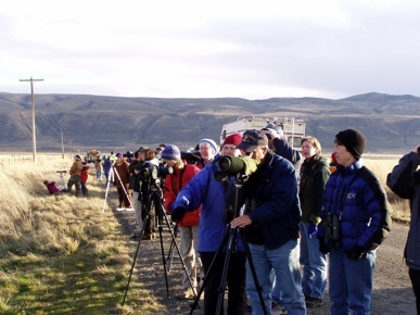
Sandhill Crane Festival photo: John Osborn
